Khajjiar is a hill station in Chamba district, Himachal Pradesh, India, located approximately 24 kilometres (15 mi) from Dalhousie.
Khajjiar sits on a small plateau with a small stream-fed lake in the middle that has been covered over with weeds. The hill station is surrounded by meadows and forests. It is about 2,000 metres (6,500 ft) above sea level in the foothills of the Dhauladhar ranges of the Western Himalayas and peaks can be seen in the distance. It is part of the Kalatop Khajjiar Sanctuary.
Khajjiar can be reached from Dalhousie, the nearest major town and hill station, by bus in an hour or so. It has a rare combination of three ecosystems: lake, pasture and forest.
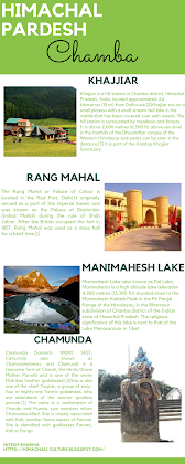 On 7 July 1992, Swiss Envoy Willy P. Blazer, Vice Counselor and Head of Chancery of Switzerland in India brought Khajjiar on the world tourism map by calling it "Mini Switzerland". He also put a sign of a yellow Swiss hiking footpath showing Khajjiar's distance from the Swiss capital Berne: "6,194 km" or 3,849 mi. Khajjiar is among the 160 locations in the world that bear topographical resemblance with Switzerland. The counselor also took from Khajjiar a stone which will form part of a stone collage around the Swiss Parliament to remind the visitors of Khajjiar as a "Mini Switzerland of India".
There is a hotel and some cottages run by HP Tourism at Khajjiar where the tourists can stay. Besides that, there are two rest houses one each of P.W.D. and Forest Department. A couple of private hotels have also come up, which do not match the above places in terms of location and amenities.
Places of interest
The best entertainment in Khajjiar is to walk around the lake or to go for long walks in the thick pine forests. In winter there is snow which can be up to 910 mm (3 ft) of height. Children enjoy this place because of the freedom of movement and the sloped terrain which permits them to roll down to the lake without getting hurt. Another attraction is horse riding. There is a huge Hanuman Statue and a park.
Dauladhar mountains
Dense deodars, pines and lush green meadows are characteristic of Khajjiar. Since Khajjiar is situated at the base of the Dauladhar mountains, the tourists here can get panoramic views of the mountains.
Kalatop Khajjiar Sanctuary
The Kalatop Khajjiar Sanctuary is a wildlife sanctuary which has a wide variety of flora and fauna. It is densely covered with deodar and fir forest. The place is a favorite spot for picnics and trekking.
Khajjiar Lake
Khajjiar Lake is a small lake, surrounded by saucer-shaped lush green meadow and a floating island. The dense growth of weed called vacha has made its earth spongy. Now the banks stand covered by a thick layer of earth, formed by the years of dust settling down on the weeds.
Khajji Nag temple
A little away from the lake is the temple of Khajji Nag belonging to the 12th century CE made by the king of Chamba, Prithvi Singh. The temple has a golden dome due to which it is also known as Golden Devi Temple. In the mandapa of the temple one can see the images of the Pandavas and the defeated Kauravas hanging from the roof of the circumambulatory path. The sanctum of the temple has been carved from wood.This temple is dedicated to snake (Nāga) worship and there are some snake idols inside. The temple also has idols of Shiva and Goddess Hadimba.
The Rang Mahal or Palace of Colour is located in the Red Fort, Delhi.
It originally served as a part of the imperial harem and was known as the Palace of Distinction (Imtiaz Mahal) during the rule of Shah Jahan. After the British occupied the fort in 1857, Rang Mahal was used as a mess hall for a brief time.
The building's interior was once richly painted and decorated. Some apartments of this building are called Shish Mahal due to tiny pieces of mirrors that cover the ceilings.
Through the center of the marble palace, a shallow canal called the Stream of Paradise (Nahr-i-Bihist) flowed into a marble basin carved into the floor. Under the Rang Mahal was a basement (tehkhana), which women would use on hot summer days.
Manimahesh Lake (also known as Dal Lake, Manimahesh) is a high altitude lake (elevation 4,080 metres (13,390 ft)) situated close to the Manimahesh Kailash Peak in the Pir Panjal Range of the Himalayas, in the Bharmour subdivision of Chamba district of the Indian state of Himachal Pradesh. The religious significance of this lake is next to that of the Lake Manasarovar in Tibet.
The lake is the venue of a highly revered pilgrimage trek undertaken during the month of August/September corresponding to the month of Bhadon according to Hindu calendar, on the eighth day of the New Moon period. It is known as the ‘Manimahesh Yatra’. The Government of Himachal Pradesh has declared it as a state-level pilgrimage.
There are two trekking routes to the lake. One is from Hadsar village that is mostly frequented by pilgrims and trekkers. This route is easier and have adequate arrangement for basic food and accommodation during the pilgrimage season. The other one is from village Holi, which is for the more adventurous ones. This route climbs up further and then descends to the lake, providing a beautiful view. There is no other habitation, except for a small village on this route.

A small lake with pilgrims living in tents during the annual - Manimahesh Yatra The lake, of glacial origin, is in the upper reaches of the Ghoi nala(refer Leomann maps:India Himalaya Map 4) which is tributary of Budhil river, a tributary of the Ravi River in Himachal Pradesh. However, the lake is the source of a tributary of the Budhil River, known as ‘Manimahesh Ganga’. The stream originates from the lake in the form of a fall at Dhancho. The mountain peak is a snow clad tribal glen of Brahamur in the Chamba district of manimahesh range. The highest peak is the Mani Mahesh Kailas, also called ‘Chamba Kailash' (elevation 5,656 metres or 18,556 ft) overlooking the lake. The lake, considered a glacial depression, is sourced by snow-melt waters from the surrounding hill slopes. Towards the end of June with ice beginning to melt, numerous small streams break up everywhere, which together with the lush green hills and the myriad of flowers give the place a truly remarkable view. The snow field at the base of the mountain is called by the local people as Shiva’s Chaugan Shiva's playground. According to a belief, Lord Shiva stayed here with his consort Parvati.
Manimahesh is approached from three routes. Pilgrims from Lahaul and Spiti pass through Kugti pass. Pilgrims from Kangra and Mandi take the Karwarsi pass or Jalsu pass via Tyari village, near Holi in Bharmour. The easiest and popular route is from Chamba via Bharmour. The most popular is the Bhanrlour–Hadsar-Manimahesh route which involves a 13 kilometres (8.1 mi) track from Hadsar village to the Manimahesh Lake. The highest altitude touched in this route is 4,115 metres (13,501 ft) and it takes two days with an overnight stay at Dhancho. Season to be undertaken is June to October and it has a gentle grade. The path leading to the lake is well maintained.
Halfway up this track is 6 kilometres (3.7 mi) of open and flat meadow land to Dhancho. Tented accommodation is available here during August–September. Night halt is preferred here. Free kitchens are opened by people to feed pilgrims. But many prefer to go and pitch their tents next to the lake to feel a divine experience. En route, there is waterfall at Gauri Nallah known as the Dhancho fall. From Dhancho, it is a steep climb. This track has seen lot of improvements over the years. In the past the first climb was first done by crossing Dhancho nalla. It was so tough that people used to crawl to get across. Since they used to crawl like a monkey in this stretch it was known as 'Bandar Ghati' (monkey valley). Now this track is much improved and the newly constructed path is used. However, some still prefer to take the old route as an adventure and go through the Bandar Ghati.
In the past, on the trek from Dhancho, the bridge over the Mani Mahesh river was crossed to reach the left bank of the valley. After 2 kilometres (1.2 mi), the river was again crossed, over another wooden bridge, to the right bank.
From this point, the climb passes through many zigzag paths along flowered meadows. Birch trees are seen in the vicinity, which indicates a gain in altitude as the trek proceeds. Along this stretch of the trek route, there are a number community kitchens (eateries) at about 3,600 metres (11,800 ft) elevation. From this location, the trail to Mani Mahesh Lake could be discerned. The waterfall, flowing from the lake, is also seen at this stage. A further trek of 1.5 kilometres (0.93 mi) through the grassy ridges leads to the Manimahesh Lake.
Chamunda (Sanskrit: चामुण्डा, IAST: Cāmuṇḍā) also known as Chamundeshwari, and Chamundi is a fearsome form of Chandi, the Hindu Divine Mother Parvati and is one of the seven Matrikas (mother goddesses).
She is also one of the chief Yoginis, a group of sixty-four or eighty-one Tantric goddesses, who are attendants of the warrior goddess parvati. The name is a combination of Chanda and Munda, two monsters whom Chamunda killed. She is closely associated with Kali, another fierce aspect of Parvati. She is identified with goddesses Parvati, Kali or Durga.
The goddess is often portrayed as haunting cremation grounds or fig trees. The goddess is worshipped by ritual animal sacrifices along with offerings of wine and in ancient times, human sacrifices were offered too.[citation needed] The practice of animal sacrifices has become less common with Shaivite and Vaishnavite influences.
Ramakrishna Gopal Bhandarkar says that Chamunda was originally a tribal goddess, worshipped by the tribals of the Vindhya mountains in central India. These tribes were known to offer goddesses animal as well as human sacrifices along with rituals offering liquor. These methods of worship were retained in Tantric worship of Chamunda, after assimilation into Hinduism. He proposes the fierce nature of this goddess is due to her association with Vedic Rudra (identified as Shiva in modern Hinduism), identified with fire god Agni at times. Wangu also backs the theory of the tribal origins of the goddess.
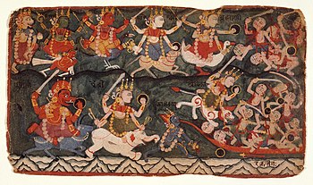
The Goddess Ambika (here identified with: Durga or Chandi) leading the Eight Matrikas in Battle Against the Demon Raktabija, Folio from a Devi Mahatmya - (top row, from the left) Narashmi, Vaishnavi, Kumari, Maheshvari, Brahmi. (bottom row, from left) Varahi, Aindri and Chamunda, drinking the blood of demons (on right) arising from Raktabija's blood and Ambika. In Hindu scripture Devi Mahatmya, Chamunda emerged as Chandika Jayasundara from an eyebrow of goddess Kaushiki, a goddess created from "sheath" of Durga and was assigned the task of eliminating the demons Chanda and Munda, generals of demon kings Shumbha-Nishumbha. She fought a fierce battle with the demons, ultimately killing them.
According to a later episode of the Devi Mahatmya, Durga created Matrikas from herself and with their help slaughtered the demon army of Shumbha-Nisumha. In this version, Kali is described as a Matrika who sucked all the blood of the demon Raktabija, from whose blood drop rose another demon. Kali is given the epithet Chamunda in the text. Thus, the Devi Mahatmya identifies Chamunda with Kali.
In the Varaha Purana, the story of Raktabija is retold, but here each of Matrikas appears from the body of another Matrika. Chamunda appears from the foot of the lion-headed goddess Narasimhi. Here, Chamunda is considered a representation of the vice of tale-telling (pasunya). The Varaha Purana text clearly mentions two separate goddesses Chamunda and Kali, unlike Devi Mahatmya.
According to another legend, Chamunda appeared from the frown of the benign goddess Parvati to kill demons Chanda and Munda. Here, Chamunda is viewed as a form of Parvati.
The Matsya Purana tells a different story of Chamunda's origins. She with other matrikas was created by Shiva to help him kill the demon Andhakasura, who has an ability - like Raktabija - to generate from his dripping blood. Chamunda with the other matrikas drinks the blood of the demon ultimately helping Shiva kill him. Ratnakara, in his text Haravijaya, also describes this feat of Chamunda, but solely credits Chamunda, not the other matrikas of sipping the blood of Andhaka. Having drunk the blood, Chamunda's complexion changed to blood-red.The text further says that Chamunda does a dance of destruction, playing a musical instrument whose shaft is Mount Meru, the string is the cosmic snake Shesha and gourd is the crescent moon. She plays the instrument during the deluge that drowns the world.
Created By :-
Nitesh Sharma


Comments
Post a Comment