Posts

Hamirpur Himachal Pradesh

Image
  Hamirpur is smallest district in himachal pradesh . It is covered by Shivalik Ranges. Hamirpur is located in the Lower West Central Outer Himalayas at an average elevation of 790 M above sea level. Far northern High Altitude Dhauladhar Ranges overlook the city. Monsoon season starts in late June and lasts till early September with fair amount of rainfall. It snowed in some parts of the district in January 2012 and February 2019 respectively. It lies beneath the irregular pattern hills Of Lower Western Himalayas and southern Shivalik Ranges. It has a fair amount of pine forests. Temples Shri Siddh Baba Balak Nath Temple, Deotsidh, is the biggest holy shrine in Barsar tehsil of the district. It is situated on the Deotsidh Dhar Range in Sivalik Hills. It stretches across 44 kilometers from Hamirpur, 185 kilometers from Chandigarh, 93 kilometers from Nangal Dam railway station, 64 kilometers from Una, 16 kilometers from Barsar and about 5 kilometers from Shah Talai. The ancient Gasoteshw

Nalwari Fair Bilaspur Himachal Pardesh

Image
  Nalwari fair Bilaspur Town Of Hmachal Pardesh Nalwari Fair very famous in all state and distt. Nalwari fair start on every year 17 march to 23-24 march.  17 march to 19 march all distt. people show your animals  to win a price. fair unions decided price to most artrective animals.  This fair organized to lunu ground bilaspur.  Nalwari fair shows bilaspur and Himachali Culture .  after 19 march start wrestling and several other  fun activities. these activities end on 23 of march. after 21 march every night come singer and culture artiest in the fair. the main famous singer come 23 of night. 23 march 2019 come nalwari fair famous punjabi singer satinder  sartaj and 23 march 2018 og night come nooran sisters in nalwari fair. Nalwari fair celebrated on distt. and state level. this fair very interesting and people lot of enjoy these day every year month of march. we requested to all people come and enjoy this fair. 

Mandi (Himachal Pardesh)

Image
Prashar Lake Prashar Lake  lies 49 km east of  Mandi ,  Himachal Pradesh ,  India , with a three storied  pagoda -like temple dedicated to the sage Prashar.   The lake is located at a height of 2,730 m (8,960 ft) above sea level. With deep blue waters, the lake is held sacred to the sage Prashar and he is regarded to have meditated there. Surrounded by snow-capped peaks and looking down on the fast flowing river Beas, the lake can be approached from   Mandi   or from Bajaura in   Kullu Valley . Both routes are 49 km (30 mi). There is a round, floating island in the lake, which is a common natural phenomenon found all around the world.   It is composed of plant matter in various stages of decomposition, and is held aloft by the oxygen in its plants' roots. The floating island moves in all directions in the lake. The floating land covers 7% of the area of the lake. Temple view, Prashar Lake The temple was built in the thirteenth century and legend has it was built by a baby from a

Bilaspur ( Himachal Pradesh)

Image
  Bilaspur , Himachal Pradesh Bilaspur is a small district of Himachal Pradesh. It is on the banks of Govind Sagar Lake. Bilaspur is also known from Khelur. The town of Bilaspur was founded in 1663.  Famous places to visit Koldam Dam The Koldam Hydropower Station commonly known as Koldam, is an embankment dam on the Satluj River upstream of the Dehar Power House. It is 18 km from Bilaspur off the Chandigarh-Manali Highway (NH-21) near Barmana, Himachal Pradesh, India. The main purpose of the dam is hydroelectric power generation and it will support an 800 MW power station. The dam was constructed by National Thermal Power Corporation (NTPC). The foundation stone for the dam was laid on 5 June 2000 by Prime Minister Atal Bihari Vajpayee. On 14 January 2004, main construction on the dam began.Due to problems associated with habitat and forest loss, the project has been delayed. Attempts to impound the reservoir first failed in December 2013 due to problems with sealing the diversion tun

Chamba (Himachal Pradesh)

Image
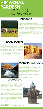
       Khajjiar                                                                                                         Khajjiar  is a  hill station  in  Chamba district ,  Himachal Pradesh ,  India , located approximately 24 kilometres (15 mi) from  Dalhousie . Khajjiar sits on a small plateau with a small stream-fed lake in the middle that has been covered over with weeds. The hill station is surrounded by meadows and forests. It is about 2,000 metres (6,500 ft) above sea level in the foothills of the  Dhauladhar  ranges of the Western  Himalayas  and peaks can be seen in the distance. It is part of the  Kalatop Khajjiar Sanctuary . Khajjiar can be reached from Dalhousie, the nearest major town and hill station, by bus in an hour or so. It has a rare combination of three  ecosystems :  lake ,  pasture  and  forest . On 7 July 1992, Swiss Envoy Willy P. Blazer, Vice Counselor and Head of Chancery of Switzerland in India brought Khajjiar on the world tourism map by calling it "Min

Popular posts from this blog

Mandi (Himachal Pardesh)

Bilaspur ( Himachal Pradesh)

HISTORY AND CULTURE OF HIMACHAL PRADESH